About Us

About Aerial Diagrams

Discover an Advanced Level of
Measurement

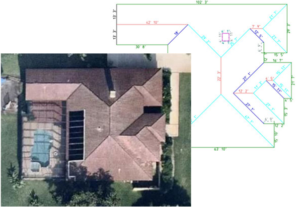
Aerial Diagrams is proud to offer Aerial Roof Measurement sevices to the roofing industry. We use the latest in technology and highest quality aerial and satellite images to create our roofing measurements. Using these images together with our web based software, we are able to create a roof take-off that is just as accurate as on-site measurements. In fact, our roofing measurements have been proven accurate to within 2%-5% and fastest report delivery compare to other Aerial Roof Measurement Companies.

Our Goal & Specialization

Our goal at Aerial Diagrams is to streamline your day to day operations by automating your employees and allowing them to work more efficiently with the help of our interactive Roof Reports. When your roof report is ready, it is not just emailed to one person, or available for download into a single desktop application, it is available to anyone in your company using a web based user account. All your reports saved on our database and you can view and download any time as per your convenience. Our 3D Roof reports include Aerial Images, rakes, flashing, valleys, ridges, multiple slope areas, pitch, linear measurements, total squares, recommended waste, etc. Our System can Export and import file formats such as XML,RFX,DFX/DWG and WRL.